
Lincoln County topographic map
Interactive map
Click on the map to display elevation.
About this map
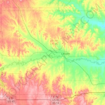
Name: Lincoln County topographic map, elevation, terrain.
Location: Lincoln County, Kansas, United States (38.87083 -98.49020 39.21980 -97.92835)
Average elevation: 466 m
Minimum elevation: 393 m
Maximum elevation: 567 m
Other topographic maps
Click on a map to view its topography, its elevation and its terrain.
St. John
United States > Kansas > Stafford County
St. John, Stafford County, Kansas, 67576, United States
Average elevation: 581 m
Wichita County
United States > Kansas > Wichita County
Wichita County, Kansas, United States
Average elevation: 1,004 m