
Olympic National Park topographic map
Interactive map
Click on the map to display elevation.
About this map
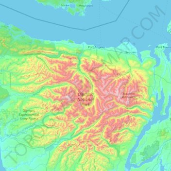
Name: Olympic National Park topographic map, elevation, terrain.
Average elevation: 412 m
Minimum elevation: -3 m
Maximum elevation: 2,367 m
Views of the Olympic National Park can be seen from the Hurricane Ridge viewpoint. The road leading west from the Hurricane Ridge visitor center has several picnic areas and trail heads. A paved trail called the Hurricane hill trail is about 1.6 miles long (one-way) with an elevation gain of about 700 feet. It is not uncommon to find snow on the trails even as late as July. Several other dirt trails of varying distances and difficulty levels branch off of the Hurricane hill trail. The picnic areas are open only in the summer, and have restrooms, water and paved access to picnic tables.
Other topographic maps
Click on a map to view its topography, its elevation and its terrain.
Skykomish
United States of America > Washington > Skykomish
Skykomish, King County, Washington, United States of America
Average elevation: 441 m
Island County
United States of America > Washington
Island County, Washington, United States of America
Average elevation: 98 m
Clallam County
United States of America > Washington
Clallam County, Washington, United States of America
Average elevation: 335 m