Geolocate

West Pensacola topographic map

Interactive map

Click on the map to display elevation.

About this map

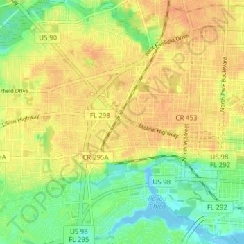
Name: West Pensacola topographic map, elevation, terrain.

Location: West Pensacola, Pensacola, Escambia County, Florida, United States (30.39782 -87.29297 30.45150 -87.24021)

Average elevation: 20 m

Minimum elevation: -4 m

Maximum elevation: 34 m

West Pensacola is located at 30°25′39″N 87°15′39″W / 30.42750°N 87.26083°W / 30.42750; -87.26083 (30.427547, -87.260720), or about 4 miles (6 km) west of downtown Pensacola. The elevation of the CDP is 76 feet above sea level.

Wikipedia (CC-BY-SA 3.0)

Other topographic maps

Click on a map to view its topography, its elevation and its terrain.

Bohemia

United States > Florida > Escambia County > Pensacola

Bohemia, Pensacola, Escambia County, Florida, 32504, United States

Average elevation: 15 m

Pensacola

United States > Florida > Escambia County > Pensacola

Pensacola, Escambia County, Florida, 32501, United States

Average elevation: 9 m

East Pensacola Heights

United States > Florida > Escambia County > Pensacola

East Pensacola Heights, Pensacola, Escambia County, Florida, 32520, United States

Average elevation: 8 m

Gull Point

United States > Florida > Escambia County > Pensacola > Gull Point

Gull Point, Pensacola, Escambia County, Florida, 32504, United States

Average elevation: 10 m