
Laurel Springs topographic map
Interactive map
Click on the map to display elevation.
About this map
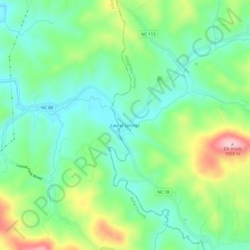
Name: Laurel Springs topographic map, elevation, terrain.
Average elevation: 893 m
Minimum elevation: 821 m
Maximum elevation: 1,045 m
Other topographic maps
Click on a map to view its topography, its elevation and its terrain.
Piney Creek
United States > North Carolina > Alleghany County
Piney Creek, Alleghany County, North Carolina, 28663, United States
Average elevation: 839 m
Roaring Gap
United States > North Carolina > Alleghany County
Roaring Gap, Alleghany County, North Carolina, 28668, United States
Average elevation: 840 m
Sparta
United States > North Carolina > Alleghany County
Sparta, Alleghany County, North Carolina, 28675, United States
Average elevation: 893 m