
Parque Popular topographic map
Interactive map
Click on the map to display elevation.
About this map
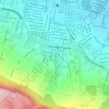
Name: Parque Popular topographic map, elevation, terrain.
Location: Parque Popular, Tuxtla Gutiérrez, Chiapas, México (16.73306 -93.11750 16.73358 -93.11690)
Average elevation: 639 m
Minimum elevation: 525 m
Maximum elevation: 926 m
Other topographic maps
Click on a map to view its topography, its elevation and its terrain.
1 de Mayo
México > Chiapas > Tuxtla Gutiérrez > 1 de Mayo
1 de Mayo, Tuxtla Gutiérrez, Chiapas, 29020, México
Average elevation: 649 m
Nuevo Eden
México > Chiapas > Tuxtla Gutiérrez > Terán > Nuevo Eden
Nuevo Eden, Tuxtla Gutiérrez, Chiapas, 29057, México
Average elevation: 678 m
Calichal
México > Chiapas > Tuxtla Gutiérrez > Calichal
Calichal, Tuxtla Gutiérrez, Chiapas, 29030, México
Average elevation: 626 m