
Westwood topographic map
Interactive map
Click on the map to display elevation.
About this map
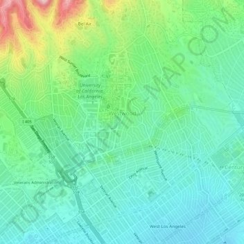
Name: Westwood topographic map, elevation, terrain.
Average elevation: 120 m
Minimum elevation: 56 m
Maximum elevation: 294 m
Other topographic maps
Click on a map to view its topography, its elevation and its terrain.
Bel-Air
United States of America > California > Los Angeles
Bel-Air, Los Angeles, Los Angeles County, California, United States of America
Average elevation: 291 m
Baldwin Hills/Crenshaw
United States of America > California > Los Angeles
Baldwin Hills/Crenshaw, Los Angeles, Los Angeles County, California, United States of America
Average elevation: 66 m
Kagel Canyon Park
United States of America > California > Los Angeles
Kagel Canyon Park, Los Angeles, Los Angeles County, California, United States of America
Average elevation: 376 m