
Rupandehi topographic map
Interactive map
Click on the map to display elevation.
About this map
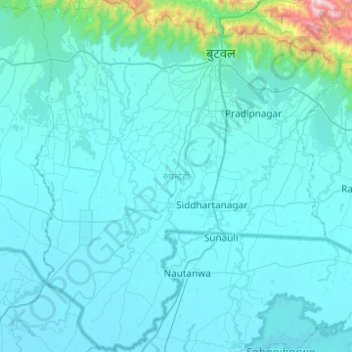
Name: Rupandehi topographic map, elevation, terrain.
Location: Rupandehi, Province #5, Nepal (27.33016 83.20425 27.76729 83.63440)
Average elevation: 182 m
Minimum elevation: 86 m
Maximum elevation: 1,800 m
The district lies on the southern and western part of Nepal. On the East it shares border with Nawalparasi District, on West with Kapilvastu District, on North with Palpa District and on South with India. The elevation of the district lies between 100m to 1229m from sea level. The total area of the district is 1,360 km² with 16.1% in Churia Range and rest in the Terai region.
Other topographic maps
Click on a map to view its topography, its elevation and its terrain.
Baba Chok
Nepal > Kathmandu > Kageshwori Manohara
Baba Chok, Kageshwori Manohara, Kageshwori Manohara Municipality, Kathmandu, Bagmati Pradesh, 20187, Nepal
Average elevation: 1,339 m
Kathmandu
Nepal > Central Development Region > Kathmandu
Kathmandu, Bagmati, Central Development Region, Nepal
Average elevation: 1,331 m
Budhanilkantha
Budhanilkantha, Kathmandu, Bagmati Pradesh, Nepal
Average elevation: 1,604 m
Western Rukum District
Western Rukum District, Karnali Pradesh, Nepal
Average elevation: 2,182 m
Musikot
Nepal > Mid-Western Development Region > Musikot
Musikot, Western Rukum District, Mid-Western Development Region, Karnali Pradesh, 22000, Nepal
Average elevation: 1,594 m
Pyuthan
Nepal > Mid-Western Development Region > Pyuthan
Pyuthan, Rapti, Mid-Western Development Region, Nepal
Average elevation: 1,261 m
Govindpur Taregana
Govindpur Taregana, Lahan, Siraha, Province #2, Nepal
Average elevation: 197 m
Hardia Chauki
Nepal > Shripur Chatiwan > Hardia Chauki
Hardia Chauki, Shripur Chatiwan, Bakaiya, Makwanpur, Bagmati Pradesh, Nepal
Average elevation: 301 m
Valayadanda
Valayadanda, Udayapurgadhi, Udayapur, Province #1, Nepal
Average elevation: 574 m
Barhabise
Nepal > Far-Western Development Region > Barhabise
Barhabise, Bajura, Seti, Far-Western Development Region, Sudurpashchim Pradesh, Nepal
Average elevation: 1,379 m
Eastern Development Region
Eastern Development Region, Koshi Province, Nepal
Average elevation: 2,441 m
Kathmandu
Nepal > Bagmati Pradesh > Kathmandu
Kathmandu, Bagmati Pradesh, 46600, Nepal
Average elevation: 1,538 m
Mid-Western Development Region
Mid-Western Development Region, Karnali Pradesh, Nepal
Average elevation: 2,083 m
Tamakoshi Nadi
Nepal > Bagmati Pradesh > Namdu
Tamakoshi Nadi, Namdu, Baiteshwor, Dolakha, Bagmati Pradesh, 0456, Nepal
Average elevation: 1,782 m
Mulpani
Nepal > Central Development Region > Mulpani
Mulpani, Dhading, Bagmati, Central Development Region, Nepal
Average elevation: 931 m
Mulpani Pipalbot
Nepal > Central Development Region > Mulpani Pipalbot
Mulpani Pipalbot, Kathmandu, Bagmati, Central Development Region, 97701, Nepal
Average elevation: 1,336 m
Ghandruk
Nepal > Western Development Region > Ghandruk > Ghandruk
Ghandruk, Annapurna, Kaski, Gandaki Pradesh, Nepal
Average elevation: 3,527 m
Chaurikharka
Nepal > Eastern Development Region > Chaurikharka
Chaurikharka, Solukhumbu, Sagarmatha, Eastern Development Region, Nepal
Average elevation: 4,307 m
Chhaling
Nepal > Central Development Region > Bhaktapur
Chhaling, Bhaktapur, Bagmati, Central Development Region, 48000, Nepal
Average elevation: 1,399 m
Maharajganj
Nepal > Western Development Region > Maharajganj
Maharajganj, Kapilvastu, Lumbini, Western Development Region, Nepal
Average elevation: 102 m
Koshi
Nepal > Eastern Development Region
Koshi, Eastern Development Region, Nepal
Average elevation: 1,899 m
Muna
Nepal > Western Development Region > Muna
Muna, Myagdi, Dhaulagiri, Western Development Region, Nepal
Average elevation: 2,230 m
Ghaghara River
Nepal > Mid-Western Development Region
Ghaghara River, Dailekh, Bheri, Mid-Western Development Region, 271833, Nepal
Average elevation: 1,522 m
Darling
Nepal > Western Development Region > Darling
Darling, Gulmi, Lumbini, Western Development Region, Nepal
Average elevation: 1,681 m
Karnali
Nepal > Mid-Western Development Region
Karnali, Mid-Western Development Region, Nepal
Average elevation: 4,062 m
Island Peak
Nepal > Eastern Development Region > Khumjung
Island Peak, Khumjung, Solukhumbu, Sagarmatha, Eastern Development Region, Nepal
Average elevation: 5,461 m
Annapurna I
Nepal > Western Development Region > Ghandruk
Annapurna I, Ghandruk, Kaski, Gandaki, Western Development Region, Nepal
Average elevation: 7,127 m
Himalayas
Nepal > Eastern Development Region > Khumjung
Himalayas, Khumjung, Solukhumbu, Sagarmatha, Eastern Development Region, Nepal
Average elevation: 7,555 m