
Price topographic map
Interactive map
Click on the map to display elevation.
About this map
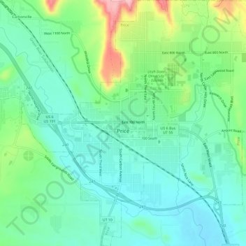
Name: Price topographic map, elevation, terrain.
Location: Price, Carbon County, Utah, 84591, United States (39.57867 -110.83472 39.62289 -110.77818)
Average elevation: 1,711 m
Minimum elevation: 1,666 m
Maximum elevation: 1,829 m
Other topographic maps
Click on a map to view its topography, its elevation and its terrain.
Carbonville
United States > Utah > Carbon County
Carbonville, Carbon County, Utah, 84591, United States
Average elevation: 1,741 m
Clear Creek
United States > Utah > Carbon County
Clear Creek, Carbon County, Utah, United States
Average elevation: 2,726 m
Helper
United States > Utah > Carbon County
Helper, Carbon County, Utah, United States
Average elevation: 1,912 m
Price
United States > Utah > Carbon County > Price > Price
Price, Carbon County, Utah, 84501, United States
Average elevation: 1,728 m
Scofield Reservoir
United States > Utah > Carbon County
Scofield Reservoir, Carbon County, Utah, United States
Average elevation: 2,435 m
Scofield
United States > Utah > Carbon County
Scofield, Carbon County, Utah, United States
Average elevation: 2,499 m