
Rostov Oblast topographic map
Interactive map
Click on the map to display elevation.
About this map
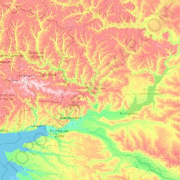
Name: Rostov Oblast topographic map, elevation, terrain.
Location: Rostov Oblast, Southern Federal District, Russia (45.95169 38.22089 50.21445 44.32415)
Average elevation: 102 m
Minimum elevation: -4 m
Maximum elevation: 359 m
Other topographic maps
Click on a map to view its topography, its elevation and its terrain.
Водолазово
Russia > Tyumen Oblast > Тушнолобовское сельское поселение > Водолазово
Average elevation: 74 m
Заозерье
Russia > Moscow Oblast > городской округ Павловский Посад > Заозерье
Average elevation: 138 m
Максимова
Russia > Tyumen Oblast > Тушнолобовское сельское поселение > Максимова
Average elevation: 75 m