
Cedar Knolls topographic map
Interactive map
Click on the map to display elevation.
About this map
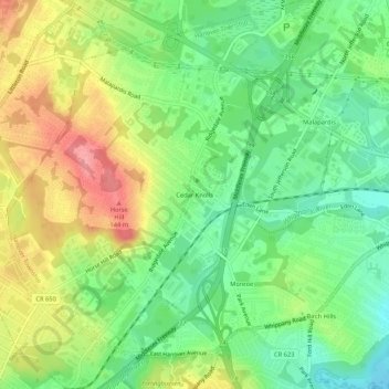
Name: Cedar Knolls topographic map, elevation, terrain.
Average elevation: 100 m
Minimum elevation: 56 m
Maximum elevation: 159 m
Other topographic maps
Click on a map to view its topography, its elevation and its terrain.
Monroe
United States > New Jersey > Morris County > Hanover Township
Monroe, Hanover Township, Morris County, New Jersey, 07927, United States
Average elevation: 93 m
Whippany
United States > New Jersey > Morris County > Hanover Township
Whippany, Hanover Township, Morris County, New Jersey, 07981, United States
Average elevation: 76 m