
Michigan topographic map
Interactive map
Click on the map to display elevation.
About this map
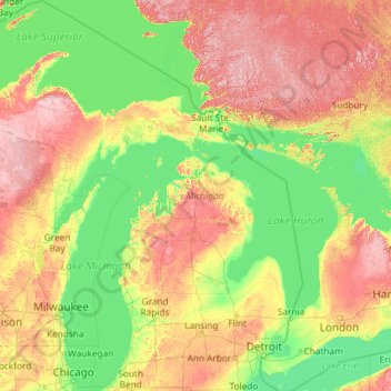
Name: Michigan topographic map, elevation, terrain.
Location: Michigan, United States (41.69613 -90.41862 48.30606 -82.12281)
Average elevation: 259 m
Minimum elevation: 169 m
Maximum elevation: 653 m
The heavily forested Upper Peninsula is relatively mountainous in the west. The Porcupine Mountains, which are part of one of the oldest mountain chains in the world, rise to an altitude of almost 2,000 feet (610 m) above sea level and form the watershed between the streams flowing into Lake Superior and Lake Michigan. The surface on either side of this range is rugged. The state's highest point, in the Huron Mountains northwest of Marquette, is Mount Arvon at 1,979 feet (603 m). The peninsula is as large as Connecticut, Delaware, Massachusetts, and Rhode Island combined but has fewer than 330,000 inhabitants. They are sometimes called "Yoopers" (from "U.P.'ers"), and their speech (the "Yooper dialect") has been heavily influenced by the numerous Scandinavian and Canadian immigrants who settled the area during the lumbering and mining boom of the late 19th century.
Other topographic maps
Click on a map to view its topography, its elevation and its terrain.
Denver
United States > Colorado > Denver County > Denver
Denver, Denver County, Colorado, United States
Average elevation: 1,684 m
San Francisco
San Francisco, California, United States
Average elevation: 63 m
Seattle
United States > Washington > King County
Seattle, King County, Washington, United States
Average elevation: 40 m
Nashville-Davidson
United States > Tennessee > Davidson County
Nashville-Davidson, Davidson County, Middle Tennessee, Tennessee, United States
Average elevation: 184 m
Virginia Beach
United States > Virginia > Virginia Beach
Virginia Beach, Virginia, 23451, United States
Average elevation: 2 m
Austin
United States > Texas > Travis County
Austin, Travis County, Texas, United States
Average elevation: 216 m
Fort Worth
United States > Texas > Tarrant County
Fort Worth, Tarrant County, Texas, United States
Average elevation: 212 m
San Diego
United States > California > San Diego County
San Diego, San Diego County, California, United States
Average elevation: 125 m
Cincinnati
United States > Ohio > Hamilton County
Cincinnati, Hamilton County, Ohio, United States
Average elevation: 222 m
Houston
United States > Texas > Harris County
Houston, Harris County, Texas, United States
Average elevation: 25 m
Chicago
United States > Illinois > Cook County
Chicago, Cook County, Illinois, United States
Average elevation: 182 m
Reno
United States > Nevada > Washoe County
Reno, Washoe County, Nevada, United States
Average elevation: 1,650 m
Grand Rapids
United States > Michigan > Kent County
Grand Rapids, Kent County, Michigan, United States
Average elevation: 216 m
Dallas
United States > Texas > Dallas County
Dallas, Dallas County, Texas, United States
Average elevation: 160 m
Phoenix
United States > Arizona > Maricopa County
Phoenix, Maricopa County, Arizona, United States
Average elevation: 481 m
Manhattan
United States > New York > New York County > New York
Manhattan, New York County, New York, United States
Average elevation: 16 m
Asheville
United States > North Carolina > Buncombe County
Asheville, Buncombe County, North Carolina, United States
Average elevation: 727 m
Central Park
United States > New York > New York County > New York
Central Park, New York County, New York, United States
Average elevation: 26 m
Saint Petersburg
United States > Florida > Pinellas County
Saint Petersburg, Pinellas County, Florida, United States
Average elevation: 4 m
Tulsa
United States > Oklahoma > Tulsa County
Tulsa, Tulsa County, Oklahoma, United States
Average elevation: 221 m
Pittsburgh
United States > Pennsylvania > Allegheny County
Pittsburgh, Allegheny County, Pennsylvania, United States
Average elevation: 303 m
Cleveland
United States > Ohio > Cuyahoga County
Cleveland, Cuyahoga County, Ohio, United States
Average elevation: 215 m
Olmsted County
Olmsted County, Minnesota, United States
Average elevation: 354 m
Sacramento County
Sacramento County, California, United States
Average elevation: 62 m
Yellowstone National Park
United States > Wyoming > Park County
Yellowstone National Park, Park County, Wyoming, United States
Average elevation: 2,450 m
Naples
United States > Florida > Collier County
Naples, Collier County, Florida, United States
Average elevation: 3 m
Greer
United States > South Carolina > Greenville County
Greer, Greenville County, South Carolina, United States
Average elevation: 279 m
Alpine
United States > Texas > Brewster County
Alpine, Brewster County, Texas, United States
Average elevation: 1,373 m
Gloucester County
Gloucester County, Virginia, United States
Average elevation: 13 m
Brooklyn
United States > New York > New York
Brooklyn, Kings County, New York, United States
Average elevation: 9 m
Weaverville
United States > North Carolina > Buncombe County
Weaverville, Buncombe County, North Carolina, United States
Average elevation: 679 m