
Shepherd topographic map
Interactive map
Click on the map to display elevation.
About this map
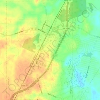
Name: Shepherd topographic map, elevation, terrain.
Location: Shepherd, San Jacinto County, Texas, 77371, United States (30.46883 -95.01910 30.51328 -94.98512)
Average elevation: 45 m
Minimum elevation: 22 m
Maximum elevation: 65 m
Other topographic maps
Click on a map to view its topography, its elevation and its terrain.
Point Blank
United States > Texas > San Jacinto County
Point Blank, San Jacinto County, Texas, United States
Average elevation: 54 m
Coldspring
United States > Texas > San Jacinto County
Coldspring, San Jacinto County, Texas, United States
Average elevation: 103 m
Pointblank
United States > Texas > San Jacinto County > Point Blank > Pointblank
Pointblank, Point Blank, San Jacinto County, Texas, 77364, United States
Average elevation: 53 m
Maynard
United States > Texas > San Jacinto County > Maynard
Maynard, San Jacinto County, Texas, United States
Average elevation: 114 m