
Mena topographic map
Interactive map
Click on the map to display elevation.
About this map
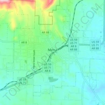
Name: Mena topographic map, elevation, terrain.
Location: Mena, Polk County, Arkansas, 72953, United States (34.55963 -94.26712 34.60503 -94.20068)
Average elevation: 355 m
Minimum elevation: 305 m
Maximum elevation: 553 m
Other topographic maps
Click on a map to view its topography, its elevation and its terrain.
Cove
United States > Arkansas > Polk County
Cove, Polk County, Arkansas, 71937, United States
Average elevation: 312 m
Bog Springs
United States > Arkansas > Polk County > Bog Springs
Bog Springs, Polk County, Arkansas, United States
Average elevation: 385 m