
Dhalai topographic map
Interactive map
Click on the map to display elevation.
About this map
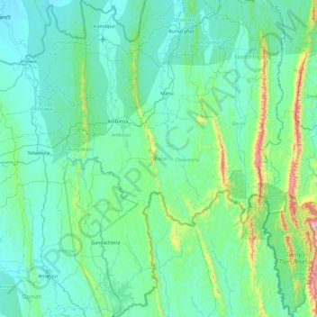
Name: Dhalai topographic map, elevation, terrain.
Location: Dhalai, Tripura, India (23.40625 91.74773 24.24118 92.17587)
Average elevation: 138 m
Minimum elevation: 15 m
Maximum elevation: 1,066 m
The climate in Setrai, which is about 40 km from Ambassa, displays characteristics that are typical of the hilly and mountainous region. The change in the topographical features, heavy rainfall and altitude of the region causes a change in the climatic conditions in Setrai. The climate and other factors of the terrain and the soil are suitable conditions for horticulture.
Other topographic maps
Click on a map to view its topography, its elevation and its terrain.
Gachirampara
Gachirampara, Dasda, North Tripura, Tripura, 799271, India
Average elevation: 93 m
Dharmanagar
Dharmanagar, Panisagar, North Tripura, Tripura, 799250, India
Average elevation: 33 m
Kamalpur
India > Tripura > Durga Chowmuhani
Kamalpur, Durga Chowmuhani, Dhalai, Tripura, 799285, India
Average elevation: 47 m
Arundhauti Nagar Children Park
India > Tripura > Dukli > Agartala
Arundhauti Nagar Children Park, Badharghat, Agartala, Dukli, West Tripura, Tripura, 799003, India
Average elevation: 18 m
Sonamura
India > Tripura > Melaghar Urban
Sonamura, Melaghar Urban, Sepahijala, Tripura, India
Average elevation: 21 m
Kailashahar
Kailashahar, Gournagar, Unokoti, Tripura, 799277, India
Average elevation: 33 m
Dumboor Lake
India > Tripura > Raishyabari > Raishyabari
Dumboor Lake, Raishyabari, Dhalai District, Tripura, India
Average elevation: 108 m
Gumti WLS
India > Tripura > Ganganagar
Gumti WLS, Ganganagar, Dhalai, Tripura, India
Average elevation: 109 m