
Christian Island topographic map
Interactive map
Click on the map to display elevation.
About this map
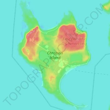
Name: Christian Island topographic map, elevation, terrain.
Average elevation: 185 m
Minimum elevation: 171 m
Maximum elevation: 259 m
Christian Island is a large island in Georgian Bay close to the communities of Penetanguishene and Midland, Ontario. The island, with its neighbours Hope Island and Beckwith Island, is a 5,428.1 hectares (13,413.1 acres) Ojibwa reserve, known as Christian Island Indian Reserve No. 30. Together with the 7.5 hectares (18.5 acres) Christian Island Indian Reserve No. 30A located at Cedar Point, Ontario and the 3.1 hectares (7.7 acres) Chippewa Island Indian Reserve located in Twelve Mile Sound, 27.5 kilometres (17.1 mi) north of Christian Island, it forms the land base for the Beausoleil First Nation. Christian Islands' highest elevation is 209 metres (686 feet) above sea level.