
Make a donation
Bloomington topographic map
Click on the map to display elevation.
Make a donation
About this map
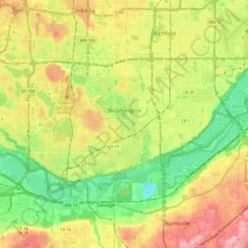
Name: Bloomington topographic map, elevation, terrain.
Location: Bloomington, Hennepin County, Minnesota, United States (44.78513 -93.39890 44.86314 -93.19741)
Average elevation: 255 m
Minimum elevation: 187 m
Maximum elevation: 343 m
Make a donation
Other topographic maps
Click on a map to view its topography, its elevation and its terrain.
Elm Creek Park (Maple Grove Arboretum)
United States > Minnesota > Hennepin County > Maple Grove
Average elevation: 278 m
Mississippi River
United States > Minnesota > Hennepin County > Minneapolis
The uppermost lock and dam on the Upper Mississippi River is the Upper St. Anthony Falls Lock and Dam in Minneapolis. Above the dam, the river's elevation is 799 feet (244 m). Below the dam, the river's elevation is 750 feet (230 m). This 49-foot (15 m) drop is the largest of all the Mississippi River locks…
Average elevation: 256 m
Make a donation
Make a donation
Wood Lake Nature Center
United States > Minnesota > Hennepin County > Richfield
Average elevation: 260 m
Eden Prairie
United States > Minnesota > Hennepin County > Eden Prairie > Eden Prairie
Average elevation: 267 m
Make a donation