
Forrest topographic map
Interactive map
Click on the map to display elevation.
About this map
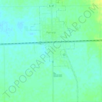
Name: Forrest topographic map, elevation, terrain.
Location: Forrest, Livingston County, Illinois, 61741, United States (40.73110 -88.41922 40.76175 -88.40027)
Average elevation: 212 m
Minimum elevation: 205 m
Maximum elevation: 224 m
Other topographic maps
Click on a map to view its topography, its elevation and its terrain.
Pontiac
United States > Illinois > Livingston County
Pontiac, Pontiac Township, Livingston County, Illinois, 61764, United States
Average elevation: 199 m
Long Point
United States > Illinois > Livingston County
Long Point, Livingston County, Illinois, United States
Average elevation: 195 m
Odell
United States > Illinois > Livingston County
Odell, Livingston County, Illinois, 60460, United States
Average elevation: 218 m
Dwight
United States > Illinois > Livingston County
Dwight, Livingston County, Illinois, United States
Average elevation: 194 m
Cornell
United States > Illinois > Livingston County > Cornell
Cornell, Amity Township, Livingston County, Illinois, 61319, United States
Average elevation: 192 m
Cornell
United States > Illinois > Livingston County
Cornell, Amity Township, Livingston County, Illinois, United States
Average elevation: 193 m