
Connecticut topographic map
Interactive map
Click on the map to display elevation.
About this map
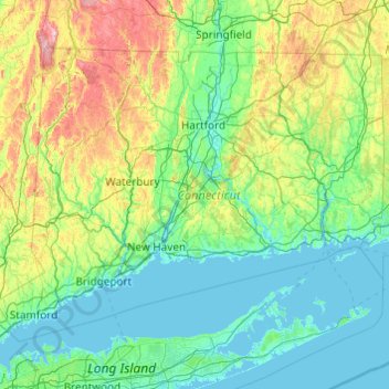
Name: Connecticut topographic map, elevation, terrain.
Location: Connecticut, USA (40.94926 -73.72778 42.05059 -71.78699)
Average elevation: 118 m
Minimum elevation: -3 m
Maximum elevation: 780 m
Other topographic maps
Click on a map to view its topography, its elevation and its terrain.
Major Island
Major Island, New London County, Connecticut, USA
Average elevation: 16 m
Morrison Hill
USA > Connecticut > Hartland
Morrison Hill, Hartland, Hartford County, Connecticut, 06091, USA
Average elevation: 289 m
New Haven
USA > Connecticut > New Haven
New Haven, New Haven County, Connecticut, USA
Average elevation: 20 m