
Komi Republic topographic map
Interactive map
Click on the map to display elevation.
About this map
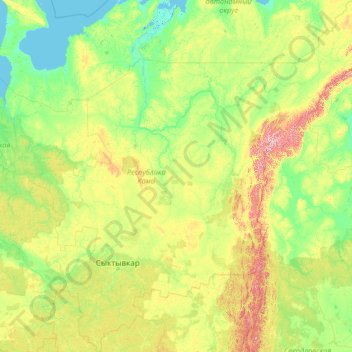
Name: Komi Republic topographic map, elevation, terrain.
Location: Komi Republic, Northwestern Federal District, Russia (59.19829 45.39935 68.42266 66.25169)
Average elevation: 140 m
Minimum elevation: -2 m
Maximum elevation: 1,629 m
Other topographic maps
Click on a map to view its topography, its elevation and its terrain.
Pechora
Russia > Komi Republic > Pechora
Pechora, Pechora Municipal District, Komi Republic, Northwestern Federal District, 169600, Russia
Average elevation: 61 m
Vychegda River
Vychegda River, Kortkerossky District, Komi Republic, Northwestern Federal District, 168071, Russia
Average elevation: 154 m