
Becker County topographic map
Interactive map
Click on the map to display elevation.
About this map
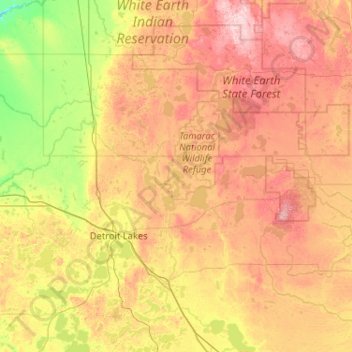
Name: Becker County topographic map, elevation, terrain.
Location: Becker County, Minnesota, United States (46.71753 -96.19484 47.15256 -95.16219)
Average elevation: 439 m
Minimum elevation: 324 m
Maximum elevation: 597 m
Becker County has diverse topography. It is home to several hundred lakes, many acres of fertile farm land, and forested areas. Much of the land consists of hills and deciduous trees.
Other topographic maps
Click on a map to view its topography, its elevation and its terrain.
Saint Paul
United States > Minnesota > Ramsey County
Saint Paul, Ramsey County, Minnesota, United States
Average elevation: 268 m
Minneapolis
United States > Minnesota > Hennepin County
Minneapolis, Hennepin County, Minnesota, United States
Average elevation: 270 m
Minneapolis
United States > Minnesota > Hennepin County > Minneapolis
Minneapolis, Hennepin County, Minnesota, 55488, United States
Average elevation: 271 m
Duluth
United States > Minnesota > Saint Louis County
Duluth, Saint Louis County, Minnesota, United States
Average elevation: 286 m
Mankato
United States > Minnesota > Blue Earth County
Mankato, Blue Earth County, Minnesota, 56001, United States
Average elevation: 285 m
Maple Grove
United States > Minnesota > Hennepin County
Maple Grove, Hennepin County, Minnesota, United States
Average elevation: 278 m
Rochester
United States > Minnesota > Olmsted County
Rochester, Olmsted County, Minnesota, United States
Average elevation: 354 m
Olmsted County
Olmsted County, Minnesota, United States
Average elevation: 354 m
Dunnell
United States > Minnesota > Martin County
Dunnell, Martin County, Minnesota, United States
Average elevation: 403 m
Gainy Park
United States > Minnesota > Steele County > Owatonna
Gainy Park, Owatonna, Steele County, Minnesota, United States
Average elevation: 359 m
Bloomington
United States > Minnesota > Hennepin County
Bloomington, Hennepin County, Minnesota, United States
Average elevation: 255 m
Crow Wing County
Crow Wing County, Minnesota, United States
Average elevation: 386 m
Glendale
United States > Minnesota > Scott County > Savage
Glendale, Savage, Scott County, Minnesota, 55378, United States
Average elevation: 262 m
Eagan
United States > Minnesota > Dakota County
Eagan, Dakota County, Minnesota, United States
Average elevation: 267 m
Itasca County
Itasca County, Minnesota, United States
Average elevation: 412 m
West St. Paul
United States > Minnesota > Dakota County
West St. Paul, Dakota County, Minnesota, 55118, United States
Average elevation: 294 m
Big Deep Lake
United States > Minnesota > Cass County
Big Deep Lake, Cass County, Minnesota, United States
Average elevation: 420 m
Oxlip
United States > Minnesota > Isanti County
Oxlip, Bradford Township, Isanti County, Minnesota, United States
Average elevation: 288 m
Crown
United States > Minnesota > Isanti County
Crown, Stanford Township, Isanti County, Minnesota, United States
Average elevation: 295 m
Weber
United States > Minnesota > Isanti County
Weber, North Branch Township, Isanti County, Minnesota, United States
Average elevation: 282 m
Walbo
United States > Minnesota > Isanti County
Walbo, Springvale Township, Isanti County, Minnesota, United States
Average elevation: 286 m
Springvale
United States > Minnesota > Isanti County
Springvale, Springvale Township, Isanti County, Minnesota, United States
Average elevation: 288 m
Pine Brook
United States > Minnesota > Isanti County
Pine Brook, Springvale Township, Isanti County, Minnesota, United States
Average elevation: 291 m
Grandy
United States > Minnesota > Isanti County
Grandy, Cambridge Township, Isanti County, Minnesota, 55029, United States
Average elevation: 285 m
Elm Park
United States > Minnesota > Isanti County
Elm Park, Maple Ridge Township, Isanti County, Minnesota, United States
Average elevation: 290 m
Stanchfield
United States > Minnesota > Isanti County
Stanchfield, Stanchfield Township, Isanti County, Minnesota, 55080, United States
Average elevation: 287 m
Bodum
United States > Minnesota > Isanti County
Bodum, Isanti Township, Isanti County, Minnesota, 55008, United States
Average elevation: 294 m
Wyanett
United States > Minnesota > Isanti County
Wyanett, Wyanett Township, Isanti County, Minnesota, United States
Average elevation: 293 m
West Point
United States > Minnesota > Isanti County
West Point, Spencer Brook Township, Isanti County, Minnesota, United States
Average elevation: 287 m
Stanley
United States > Minnesota > Isanti County
Stanley, Isanti Township, Isanti County, Minnesota, United States
Average elevation: 293 m
Stanchfield Corner
United States > Minnesota > Isanti County
Stanchfield Corner, Stanchfield Township, Isanti County, Minnesota, 55080, United States
Average elevation: 287 m
Spring Lake
United States > Minnesota > Isanti County
Spring Lake, North Branch Township, Isanti County, Minnesota, United States
Average elevation: 286 m
Spencer Brook
United States > Minnesota > Isanti County
Spencer Brook, Spencer Brook Township, Isanti County, Minnesota, United States
Average elevation: 289 m
Edgewood
United States > Minnesota > Isanti County
Edgewood, Isanti Township, Isanti County, Minnesota, 55008, United States
Average elevation: 289 m
Day
United States > Minnesota > Isanti County
Day, Maple Ridge Township, Isanti County, Minnesota, United States
Average elevation: 302 m
Dalbo
United States > Minnesota > Isanti County
Dalbo, Dalbo Township, Isanti County, Minnesota, 55017, United States
Average elevation: 296 m
Carmody
United States > Minnesota > Isanti County
Carmody, Dalbo Township, Isanti County, Minnesota, 55017, United States
Average elevation: 299 m
Blomford
United States > Minnesota > Isanti County
Blomford, Isanti Township, Isanti County, Minnesota, United States
Average elevation: 290 m
Andree
United States > Minnesota > Isanti County
Andree, Stanchfield Township, Isanti County, Minnesota, 55006, United States
Average elevation: 291 m
Isanti
United States > Minnesota > Isanti County
Isanti, Isanti County, Minnesota, United States
Average elevation: 285 m
Shorewood
United States > Minnesota > Hennepin County
Shorewood, Tonka Bay, Hennepin County, Minnesota, 55331, United States
Average elevation: 293 m
Bradford
United States > Minnesota > Isanti County
Bradford, Bradford Township, Isanti County, Minnesota, United States
Average elevation: 287 m
Athens
United States > Minnesota > Isanti County
Athens, Athens Township, Isanti County, Minnesota, 55040, United States
Average elevation: 284 m
Wayzata
United States > Minnesota > Hennepin County
Wayzata, Hennepin County, Minnesota, United States
Average elevation: 291 m
St. Vincent
United States > Minnesota > Kittson County
St. Vincent, Kittson County, Minnesota, 56755, United States
Average elevation: 241 m
Tonka Bay
United States > Minnesota > Hennepin County
Tonka Bay, Hennepin County, Minnesota, United States
Average elevation: 286 m
La Crescent
United States > Minnesota > Houston County
La Crescent, Houston County, Minnesota, 55947, United States
Average elevation: 231 m
Minnetonka Beach
United States > Minnesota > Hennepin County
Minnetonka Beach, Hennepin County, Minnesota, United States
Average elevation: 284 m
Eitzen
United States > Minnesota > Houston County
Eitzen, Houston County, Minnesota, United States
Average elevation: 342 m
Willington Grove
United States > Minnesota > Houston County
Willington Grove, Houston County, Minnesota, United States
Average elevation: 366 m