
Norfolk County topographic map
Interactive map
Click on the map to display elevation.
About this map
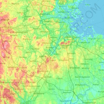
Name: Norfolk County topographic map, elevation, terrain.
Location: Norfolk County, Massachusetts, United States of America (41.98494 -71.50310 42.35177 -70.73843)
Average elevation: 47 m
Minimum elevation: -4 m
Maximum elevation: 185 m
Other topographic maps
Click on a map to view its topography, its elevation and its terrain.
Hampden County
United States of America > Massachusetts > Holyoke
Hampden County, Massachusetts, United States of America
Average elevation: 209 m