
Viralimalai topographic map
Interactive map
Click on the map to display elevation.
About this map
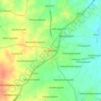
Name: Viralimalai topographic map, elevation, terrain.
Average elevation: 133 m
Minimum elevation: 113 m
Maximum elevation: 162 m
Other topographic maps
Click on a map to view its topography, its elevation and its terrain.
Ellapatti
India > Tamil Nadu > Iluppur taluk
Ellapatti, Iluppur taluk, Pudukkottai District, Tamil Nadu, India
Average elevation: 142 m
Senthamangalam
India > Tamil Nadu > Iluppur taluk > Pudukkottai
Senthamangalam, Pudukkottai, Iluppur taluk, Pudukkottai District, Tamil Nadu, India
Average elevation: 95 m