
Ob River topographic map
Interactive map
Click on the map to display elevation.
About this map
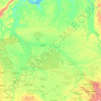
Name: Ob River topographic map, elevation, terrain.
Location: Ob River, Ural Federal District, 628179, Russia (52.30262 65.04695 66.78650 84.96865)
Average elevation: 122 m
Minimum elevation: -1 m
Maximum elevation: 2,033 m
Other topographic maps
Click on a map to view its topography, its elevation and its terrain.
Khanty-Mansiysk
Russia > Khanty-Mansiysk Autonomous Okrug – Ugra > Khanty-Mansiysk
Khanty-Mansiysk, Khanty-Mansiysk Urban Okrug, Khanty-Mansiysk Autonomous Okrug – Ugra, Ural Federal District, 628000, Russia
Average elevation: 32 m