
Bigbury topographic map
Interactive map
Click on the map to display elevation.
About this map
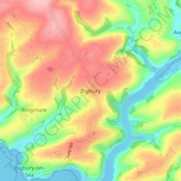
Name: Bigbury topographic map, elevation, terrain.
Average elevation: 68 m
Minimum elevation: -4 m
Maximum elevation: 139 m
Other topographic maps
Click on a map to view its topography, its elevation and its terrain.
St Ann's Chapel
United Kingdom > England > South Hams > Bigbury > St Ann's Chapel
St Ann's Chapel, Bigbury, South Hams, Devon, South West England, England, TQ7 4HQ, United Kingdom
Average elevation: 81 m