
Hudson River topographic map
Interactive map
Click on the map to display elevation.
About this map
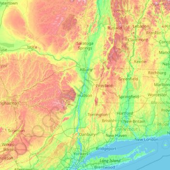
Name: Hudson River topographic map, elevation, terrain.
Location: Hudson River, New York, 12246, United States (40.65258 -74.19894 44.09099 -73.57327)
Average elevation: 297 m
Minimum elevation: -3 m
Maximum elevation: 1,402 m
The source of the Hudson River is Lake Tear of the Clouds in the Adirondack Park at an elevation of 4,322 feet (1,317 m).[25][26] However, the river is not cartographically called the Hudson River until miles downstream. The river is named Feldspar Brook until its confluence with the Opalescent River, and then is named the Opalescent River until the river reaches Calamity Brook, flowing south from the outlet of Henderson Lake. From that point on, the stream is cartographically known as the Hudson River.[27][28][29] The U.S. Geological Survey (USGS) uses this cartographical definition.[6]
Other topographic maps
Click on a map to view its topography, its elevation and its terrain.
City of Ithaca
United States > New York > Tompkins County
City of Ithaca, Tompkins County, New York, United States
Average elevation: 195 m
Walton Park
United States > New York > Orange County > Town of Monroe
Walton Park, Town of Monroe, Orange County, New York, United States
Average elevation: 213 m
Town of Lake Pleasant
United States > New York > Hamilton County
Town of Lake Pleasant, Hamilton County, New York, United States
Average elevation: 640 m
South Troy
United States > New York > Rensselaer County > City of Troy
South Troy, City of Troy, Rensselaer County, New York, 12180, United States
Average elevation: 92 m
City of Glens Falls
United States > New York > Warren County > City of Glens Falls
City of Glens Falls, Warren County, New York, 12801, United States
Average elevation: 100 m
City of Geneva
United States > New York > Ontario County > City of Geneva
City of Geneva, Ontario County, New York, 14456, United States
Average elevation: 155 m
Essex County
United States > New York > Essex County
Essex County, New York, United States
Average elevation: 418 m
Manhattan
United States > New York > New York
Manhattan, New York, United States
Average elevation: 17 m
Saratoga County
Saratoga County, New York, United States
Average elevation: 218 m
New York County
United States > New York > New York County > New York
New York County, New York, United States
Average elevation: 16 m