
Boulder County topographic map
Interactive map
Click on the map to display elevation.
About this map
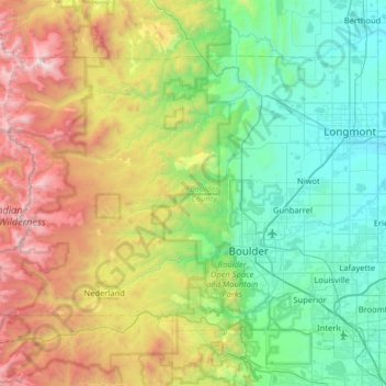
Name: Boulder County topographic map, elevation, terrain.
Location: Boulder County, Colorado, United States of America (39.91172 -105.69436 40.26297 -105.05280)
Average elevation: 2,309 m
Minimum elevation: 1,490 m
Maximum elevation: 4,340 m
Rocky Mountain National Park is in Boulder County, Larimer County, and Grand County. Longs Peak, the park's highest summit at 4,345 meters (14,255 feet) elevation, is located in Boulder County.
Other topographic maps
Click on a map to view its topography, its elevation and its terrain.
Larimer County
United States of America > Colorado
Larimer County, Colorado, United States of America
Average elevation: 2,363 m