
Make a donation
108 Mile Lake topographic map
Click on the map to display elevation.
Make a donation
About this map
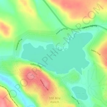
Name: 108 Mile Lake topographic map, elevation, terrain.
Average elevation: 905 m
Minimum elevation: 870 m
Maximum elevation: 955 m
Make a donation
Other topographic maps
Click on a map to view its topography, its elevation and its terrain.
Vancouver
Canada > British Columbia > Metro Vancouver Regional District
Vancouver, British Columbia, is situated on the Burrard Peninsula, bordered by Burrard Inlet to the north and the Fraser River to the south. The city's topography is a blend of flat and hilly terrains, with elevations ranging from sea level to approximately 152 meters (500 feet) above sea level. The North…
Average elevation: 34 m
Burnaby
Canada > British Columbia > Metro Vancouver Regional District
Burnaby occupies 98.6 square kilometres (38.1 sq mi) and is located at the geographic centre of the Metro Vancouver Regional District. The regional district's government is located in Burnaby's Metrotown area. Situated between the city of Vancouver on the west and Port Moody, Coquitlam, and New Westminster on…
Average elevation: 59 m
Victoria
Canada > British Columbia > Capital Regional District
Victoria, British Columbia, is situated on the southern tip of Vancouver Island, Canada, and boasts a diverse and varied topography. The city is characterized by rolling hills, rugged coastal cliffs, and lush valleys, providing a striking contrast between mountainous terrain and flatland areas. To the north…
Average elevation: 17 m
Make a donation
Coquitlam
Canada > British Columbia > Metro Vancouver Regional District > Coquitlam
Southwest Coquitlam comprises the original core of the city, with Maillardville and Fraser River industrial sector giving way to the large residential areas of Austin Heights, colloquially referred to as "The Bump" due to its high and flat plateau topography. These older residences, with larger property…
Average elevation: 230 m
Make a donation
Vancouver Island
The rain shadow effect of the island's mountains, as well as the mountains of Washington's Olympic Peninsula, creates wide variation in precipitation. The west coast is considerably wetter than the east coast. Average annual precipitation ranges from 6,650 mm (262 in) at Hucuktlis Lake on the west coast…
Average elevation: 411 m
Burnaby
Canada > British Columbia > Metro Vancouver Regional District > Burnaby
Burnaby occupies 98.60 square kilometres (38.07 sq mi) and is located at the geographic centre of the Metro Vancouver area and home to the Metro Vancouver regional government in Metrotown. Situated between the city of Vancouver on the west and Port Moody, Coquitlam, and New Westminster on the east, Burnaby is…
Average elevation: 144 m
Make a donation
Coquitlam
Canada > British Columbia > Metro Vancouver Regional District
Like much of Metro Vancouver, Coquitlam has an oceanic climate (Köppen climate type Cfb), experiencing mild temperatures and high precipitation; warm, dry summers and cool, wet winters. However, compared to most other cities in the area, precipitation is especially heavy in Coquitlam due to its proximity to…
Average elevation: 190 m
Make a donation
Township of Langley
Canada > British Columbia > Metro Vancouver Regional District
Average elevation: 47 m
Make a donation
Prince George
Canada > British Columbia > Regional District of Fraser-Fort George
The area has a humid continental climate (Köppen climate classification Dfb, Trewartha Dclo), but is close to (and once had) a subarctic climate (Dfc) as May and September averages are both close to the 10 °C (50 °F) threshold. Winters are milder than the latitude and elevation might suggest: the January…
Average elevation: 685 m
Make a donation
Kelowna
Canada > British Columbia > Regional District of Central Okanagan
Kelowna is classified as a humid continental climate or an inland oceanic climate per the Köppen climate classification system due to its coldest month having an average temperature slightly above −3.0 °C (26.6 °F) and below 0 °C (32 °F), with dry, hot, sunny summers and cool, cloudy winters, and four…
Average elevation: 704 m
Penticton
Canada > British Columbia > Regional District of Okanagan-Similkameen
Penticton is located at the geographical coordinates of 49°29′28″N 119°35′19″W / 49.49111°N 119.58861°W / 49.49111; -119.58861 (Penticton) and covers an area of 42.10 km2 (16.25 sq mi), with a maximum north–south distance of 7 km (4.3 mi) wide between the Okanagan Lake to the north…
Average elevation: 702 m
Make a donation
Mission
Canada > British Columbia > Fraser Valley Regional District
The western part of the district, the Stave Valley, is largely rural and forested but its watercourse is home to what was the largest hydroelectric project in British Columbia until the Bridge River Power Project opened in 1961. It was built by the British Columbia Electric Railway (BCER) to provide power to…
Average elevation: 345 m
Vancouver Island
The rain shadow effect of the island's mountains, as well as the mountains of Washington's Olympic Peninsula, creates wide variation in precipitation. The west coast is considerably wetter than the east coast. Average annual precipitation ranges from 6,650 mm (262 in) at Hucuktlis Lake on the west coast…
Average elevation: 411 m
Make a donation
Harrison-Chehalis Wildlife Management Area
Canada > British Columbia > Fraser Valley Regional District > Area C (Sasquatch Country) > Harrison Mills
Average elevation: 187 m
Aldergrove
Canada > British Columbia > Metro Vancouver Regional District > Township of Langley
Average elevation: 107 m
Make a donation
Pemberton
Canada > British Columbia > Squamish-Lillooet Regional District
The climate of Pemberton is very warm and dry in the summer and mild and wet in the winter. Pemberton is an ecologically complex and diverse zone which is referred to as the Coast-Interior Transition zone. Moving from west to east in the direction of the prevailing winds and taking into consideration the…
Average elevation: 1,005 m
Make a donation
Gabriola Island
Canada > British Columbia > Regional District of Nanaimo > Area B (DeCourcy/Gabriola/Mudge)
Gabriola is about 14 kilometres (9 mi) long by 4.2 kilometres (2.6 mi) wide on average with a land area of 57.6 square kilometres (22.2 sq mi). The topography varies from flat sandy beaches at sea level to forested hills rising to 160 metres (525 ft) on Stoney Ridge in the centre of the island.
Average elevation: 26 m
Saltspring Island
Canada > British Columbia > Capital Regional District > Salt Spring Island Electoral Area
Average elevation: 72 m
Okanagan Lake
Canada > British Columbia > Regional District of Central Okanagan > Kelowna
Average elevation: 1,194 m
Make a donation
Kamloops
Canada > British Columbia > Thompson-Nicola Regional District > Kamloops
Average elevation: 875 m
Vancouver
Canada > British Columbia > Metro Vancouver Regional District
Vancouver's growing season averages 237 days, from March 18 until November 10. Vancouver's 1981–2010 USDA Plant Hardiness Zone ranges from 8a to 9a depending on elevation and proximity to water.
Average elevation: 34 m
West Kelowna
Canada > British Columbia > Regional District of Central Okanagan
Average elevation: 649 m
Make a donation
Grouse Mountain
Canada > British Columbia > Metro Vancouver Regional District
Grouse Mountain is one of the North Shore Mountains of the Pacific Ranges in the District Municipality of North Vancouver, British Columbia, Canada. With a maximum elevation of over 1,200 m (4,100 feet) at its peak, the mountain is the site of an alpine ski area, Grouse Mountain Resort, which overlooks Greater…
Average elevation: 968 m
Mount Rohr
Canada > British Columbia > Squamish-Lillooet Regional District > Area B (Cayoosh/Pavilion)
Average elevation: 1,940 m
Gower Point
Canada > British Columbia > Sunshine Coast Regional District > Area E (Elphinstone)
Average elevation: 33 m
Make a donation
Revelstoke
Canada > British Columbia > Columbia-Shuswap Regional District
A small ski resort featuring a single short lift has operated on Mount MacKenzie since the 1960s, and snowcat skiing was offered for higher altitudes. A strong movement pushed to expand the entire mountain into a single resort, and construction started in the early 2000s (decade).
Average elevation: 982 m
Vancouver
Canada > British Columbia > Metro Vancouver Regional District
Vancouver, British Columbia, is situated on the Burrard Peninsula, bordered by Burrard Inlet to the north and the Fraser River to the south. The city's topography is a blend of flat and hilly terrains, with elevations ranging from sea level to approximately 152 meters (500 feet) above sea level. The North…
Average elevation: 34 m
Make a donation
Make a donation
Prince Rupert
Canada > British Columbia > North Coast Regional District
Prince Rupert Airport (YPR/CYPR) is on Digby Island. Its position is 54°17′10″N 130°26′41″W / 54.28611°N 130.44472°W / 54.28611; -130.44472, and its elevation is 35 m (116 ft) above sea level. The airport consists of one runway, one passenger terminal, and two aircraft stands. Access to…
Average elevation: 91 m
Mount Garibaldi
Canada > British Columbia > Fraser Valley Regional District > Area F (McConnell Creek/Hatzic Prairie)
Mount Garibaldi (Squamish: Nch'ḵay̓, pronounced [n̩.ʧʼqɛˀj̰]) is a dormant stratovolcano in the Garibaldi Ranges of the Pacific Ranges in southwestern British Columbia, Canada. It has a maximum elevation of 2,678 metres (8,786 feet) and rises above the surrounding landscape on the east side of the…
Average elevation: 2,146 m
Make a donation
Area K (The Arrow Lakes)
Canada > British Columbia > Regional District of Central Kootenay
Average elevation: 1,452 m
Tsawwassen
Canada > British Columbia > Metro Vancouver Regional District > Delta
Average elevation: 12 m
Area E (Beaverdell/West Boundary)
Canada > British Columbia > Regional District of Kootenay Boundary
Average elevation: 1,241 m
Make a donation
Langley Township
Canada > British Columbia > Metro Vancouver Regional District > Township of Langley > Langley Township
Average elevation: 37 m
Make a donation
North Shore Mountains
Canada > British Columbia > Metro Vancouver Regional District
Average elevation: 634 m
Make a donation
North Pender Island
Canada > British Columbia > Capital Regional District > Southern Gulf Islands Electoral Area
Average elevation: 23 m
Burnaby Mountain
Canada > British Columbia > Metro Vancouver Regional District > Burnaby
Due to its relatively high elevation, snow will often fall on the higher levels of Burnaby Mountain while rain falls in the surrounding cities. Tobogganing is a popular pastime at Centennial Park on winter days with snow.
Average elevation: 167 m
Make a donation
Area D (Elaho/Garibaldi)
Canada > British Columbia > Squamish-Lillooet Regional District
Average elevation: 1,137 m
Make a donation
Make a donation
Nicola River
The terrain of the river's basin northeast and in the area of Merritt is broad rangeland valleys, with high semi-forested plateau uplands reached by relatively gentle slopes, up to and over 2,400 metres (7,900 ft). The upper basin has a number of large lakes, the largest being Douglas Lake and Nicola Lake,…
Average elevation: 1,209 m
Make a donation
Princeton
Canada > British Columbia > Regional District of Okanagan-Similkameen
Average elevation: 710 m
Fraser River
Canada > British Columbia > Chilliwack > Hope > Deroche
Similar to the Columbia River Gorge east of Portland, Oregon, the Fraser exploits a topographic cleft between two mountain ranges separating a more continental climate (in this case, that of the British Columbia Interior) from a milder climate near the coast. When an Arctic high-pressure area moves into the…
Average elevation: 865 m
Area B (South Fraser Canyon/Sunshine Valley)
Canada > British Columbia > Fraser Valley Regional District
Average elevation: 1,174 m
Make a donation
Isintok Mountain
Canada > British Columbia > Regional District of Okanagan-Similkameen > Area F (Trout Creek Valley)
Average elevation: 1,739 m
Make a donation