
Ourense topographic map
Interactive map
Click on the map to display elevation.
About this map
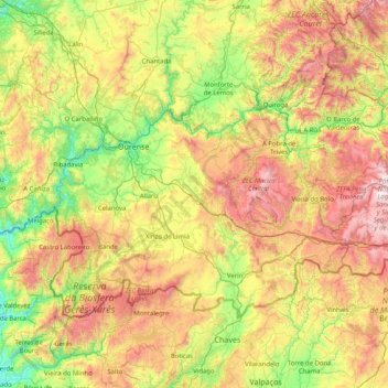
Name: Ourense topographic map, elevation, terrain.
Location: Ourense, Galicia, Spain (41.80736 -8.36634 42.57860 -6.73395)
Average elevation: 723 m
Minimum elevation: 21 m
Maximum elevation: 2,074 m
The ancient city of Auria is located on both banks of the Miño river in the south-central part of Galicia, at an elevation of 128 meters above sea level.
Other topographic maps
Click on a map to view its topography, its elevation and its terrain.
Figueiró
Spain > Galicia > O Baixo Miño > Tomiño
Figueiró, Tomiño, O Baixo Miño, Pontevedra, Galicia, 36792, Spain
Average elevation: 91 m
A Pobra do Caramiñal
Spain > Galicia > A Pobra do Caramiñal
A Pobra do Caramiñal, Teo, Galicia, Spain
Average elevation: 163 m