
Sochi topographic map
Interactive map
Click on the map to display elevation.
Sochi
Sochi has a humid subtropical climate (Köppen climate classification Cfa), at the lower elevations. Its average annual temperature is 18.9 °C (66.0 °F) during the day and 11.5 °C (52.7 °F) at night. In the coldest months—January and February—the average temperature is about 10 °C (50 °F) during the day, above 3 °C (37 °F) at night and the average sea temperature is about 9 °C (48 °F). In the warmest months—July and August—the temperature typically ranges from 25 to 29 °C (77 to 84 °F) during the day, about 20 °C (68 °F) at night and the average sea temperature is about 23–27 °C (73–81 °F). Yearly sunshine hours are around 2,200. Generally, the summer season lasts three months, from June to September. Two months—April and November—are transitional; sometimes temperatures reach 20 °C (68 °F), with an average temperature of around 16 °C (61 °F) during the day and 9 °C (48 °F) at night. December, January, February and March are the coldest months, with average temperature (of these four months) 11 °C (52 °F) during the day and 4 °C (39 °F) at night. Average annual precipitation is about 1,700 millimeters (67 in). Sochi lies at 8b/9a hardiness zone, so the city supports different types of palm trees. Sochi is situated on the same latitude as Nice but strong cold winds from Asia make winters less warm. In fact, temperatures drop below freezing every winter. The highest temperature recorded was 39.4 °C (102.9 °F), on July 30, 2000, and the lowest temperature recorded was −13.4 °C (7.9 °F) on January 25, 1892.
About this map
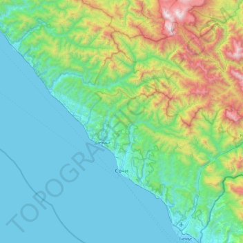
Name: Sochi topographic map, elevation, terrain.
Average elevation: 515 m
Minimum elevation: -3 m
Maximum elevation: 2,796 m