
Aiquile topographic map
Interactive map
Click on the map to display elevation.
About this map
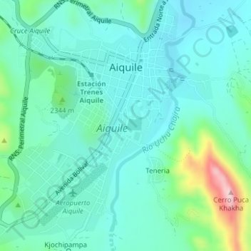
Name: Aiquile topographic map, elevation, terrain.
Location: Aiquile, Municipio Aiquile, Campero, Cochabamba, Bolivia (-18.22170 -65.20085 -18.19260 -65.16983)
Average elevation: 2,290 m
Minimum elevation: 2,232 m
Maximum elevation: 2,514 m
Other topographic maps
Click on a map to view its topography, its elevation and its terrain.
Chinguri
Bolivia > Cochabamba > Campero > Municipio Aiquile
Chinguri, Municipio Aiquile, Campero, Cochabamba, Bolivia
Average elevation: 2,042 m