
Make a donation
Mascara topographic map
Click on the map to display elevation.
Make a donation
About this map
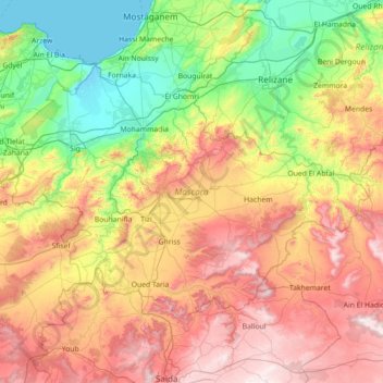
Name: Mascara topographic map, elevation, terrain.
Location: Mascara, Algeria (35.01123 -0.52186 35.78479 0.90212)
Average elevation: 469 m
Minimum elevation: -2 m
Maximum elevation: 1,269 m
Make a donation
Other topographic maps
Click on a map to view its topography, its elevation and its terrain.
Make a donation
Hoggar Mountains
Algeria > Tamanrasset > de Tamanrasset District > Tamanghasset
This mountainous region is located about 1,500 km (930 mi) south of the capital, Algiers. The area is largely rocky desert with an average elevation of more than 900 m (3,000 ft) above sea level. The highest peak, Mount Tahat, is at 2,908 m (9,541 ft). The mountains are primarily composed of metamorphic rock…
Average elevation: 2,451 m
Make a donation
Make a donation
Tahat
Algeria > Tamanrasset > de Tamanrasset District > Tamanghasset
Mount Tahat (Arabic: جبل تاهات) is the highest mountain in Algeria. It sits at an elevation of 2,908 metres (9,541 ft). Other sources indicate an elevation of 3,003 metres (9,852 ft). Tahat is also the highest peak in the Hoggar Mountains. Its nearest city is Tamanrasset which is located 56 kilometres…
Average elevation: 2,466 m
Make a donation
Make a donation
Résidence Le Badr
Algeria > Algiers > Dar el-Beida District > Bordj El Bahri > Cité 252 log
Average elevation: 14 m
Timimoun
Algeria > Timimoun Province > Timimoun District
The town of Timimoun lies at an elevation of around 288 metres (945 ft) in the Gourara region of southern Timimoun Province. It is located on the south-eastern side of an oasis which supports the town's population. A sebkha (salt lake) lies further to the northwest, while the plateau of Tademaït rises to the…
Average elevation: 274 m
Make a donation
Algiers
Algeria > Algiers > Sidi M'Hamed District > Alger-Centre
The city's downtown sits at an elevation of 2 m (at the Algiers Central Post Office), while it averages 45 m across the city's metropolitan area, and tops at 407 m on the Bouzaréah peak. Algiers Province, the administrative area that includes the city's urban and suburban centers covers 1,190 km2 (460 sq mi).
Average elevation: 45 m
Make a donation
Tahat
Algeria > Tamanrasset > de Tamanrasset District > Tamanghasset
Mount Tahat (Arabic: جبل تاهات) is the highest mountain in Algeria. It sits at an elevation of 2,908 metres (9,541 ft). Other sources indicate an elevation of 3,003 metres (9,852 ft). Tahat is also the highest peak in the Hoggar Mountains. Its nearest city is Tamanrasset which is located 56 kilometres…
Average elevation: 2,466 m
Make a donation
The subdivision Mandariniers
Algeria > Algiers > Dar el-Beida District > Al Muhammadiyya > Pins Maritimes
Average elevation: 17 m
Plage de Cap Djinet
Algeria > Boumerdès > Bordj Menaiel District > Djenet > El Mhadjer
Average elevation: 62 m
Make a donation
Make a donation
Tassili n'Ajjer
Tassili n'Ajjer lies within the West Saharan montane xeric woodlands ecoregion. Due to the higher elevation of the area, coupled with the water-retentive properties of the sandstone, the vegetation here is somewhat more lush and verdant than in the lower regions of desert; in turn, this creates an attractive…
Average elevation: 842 m
Make a donation
Hoggar Mountains
Algeria > Tamanrasset > de Tamanrasset District > Tamanghasset
This mountainous region is located about 1,500 km (930 mi) south of the capital, Algiers. The area is largely rocky desert with an average elevation of more than 900 m (3,000 ft) above sea level. The highest peak, Mount Tahat, is at 2,908 m (9,541 ft). The mountains are primarily composed of metamorphic rock…
Average elevation: 2,451 m
Make a donation
Make a donation
Erg Chech
It is an almost uninhabited part of the greater Sahara Desert, an inhospitable desert region with long, extremely hot summers and short, very warm winters. The Erg Chech is a vast sandy expanse including compound and complex linear and star dunes. The mean elevation of the Erg Chech is just above 300 m,…
Average elevation: 335 m
Make a donation
Bordj el Bahri Faizi
Algeria > Algiers > Dar el-Beida District > Bordj El Bahri
Average elevation: 19 m
Make a donation
Make a donation
The subdivision Mandariniers
Algeria > Algiers > Dar el-Beida District > Al Muhammadiyya > Pins Maritimes
Average elevation: 17 m
Algiers
Algeria > Algiers > Sidi M'Hamed District
Algiers was a walled city from the time of the deys until the close of the 19th century. The French, after their occupation of the city (1830), built a rampart, parapet and ditch, with two terminal forts, Bab Azoun باب عزون to the south and Bab-el-Oued اد to the north. The forts and part of the…
Average elevation: 45 m
Make a donation
Make a donation
Make a donation
Make a donation
Make a donation
Algiers
Algeria > Algiers > Sidi M'Hamed District > Alger-Centre
The city contains the largest infrastructure facilities in the country; railway and highway connections with neighbouring cities and international links via the Houari Boumediene Airport and Algiers Ferry Terminal. Algiers possesses notable mass transit options, that includes the Algiers Metro, the city's…
Average elevation: 45 m
Make a donation
Make a donation
Algiers
Algeria > Algiers > Sidi M'Hamed District
Algiers was a walled city from the time of the deys until the close of the 19th century. The French, after their occupation of the city (1830), built a rampart, parapet and ditch, with two terminal forts, Bab Azoun باب عزون to the south and Bab-el-Oued اد to the north. The forts and part of the…
Average elevation: 45 m
Make a donation
Ouled Chebacheb
Algeria > Boumerdès > Khemis El Khechna District > Khemis El Khechna
Average elevation: 36 m
Make a donation