
Bad Kissingen topographic map
Interactive map
Click on the map to display elevation.
About this map
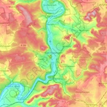
Name: Bad Kissingen topographic map, elevation, terrain.
Location: Bad Kissingen, Landkreis Bad Kissingen, Bavaria, 97688, Germany (50.14361 9.96739 50.25144 10.14263)
Average elevation: 305 m
Minimum elevation: 187 m
Maximum elevation: 419 m
Other topographic maps
Click on a map to view its topography, its elevation and its terrain.
Bad Kissingen
Germany > Bavaria > Landkreis Bad Kissingen > Bad Kissingen > Bad Kissingen
Average elevation: 295 m
Hammelburg
Germany > Bavaria > Landkreis Bad Kissingen > Hammelburg > Hammelburg
Average elevation: 260 m