
Sucre topographic map
Interactive map
Click on the map to display elevation.
About this map
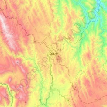
Name: Sucre topographic map, elevation, terrain.
Location: Sucre, Provincia Oropeza, Chuquisaca, 9999, Bolivia (-19.20773 -65.41943 -18.88773 -65.09943)
Average elevation: 2,829 m
Minimum elevation: 1,882 m
Maximum elevation: 3,846 m
Sucre (Spanish: ) is the constitutional capital of Bolivia, the capital of the Chuquisaca Department and the 6th most populated city in Bolivia. Located in the south-central part of the country, Sucre lies at an elevation of 2,810 meters (9,214 feet). This relatively high altitude gives the city an oceanic climate with cool temperates year-round.