
Nicolás Romero topographic map
Interactive map
Click on the map to display elevation.
About this map
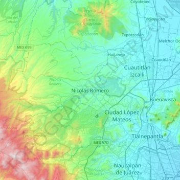
Name: Nicolás Romero topographic map, elevation, terrain.
Location: Nicolás Romero, 54476, México (19.45842 -99.46355 19.77842 -99.14355)
Average elevation: 2,502 m
Minimum elevation: 2,232 m
Maximum elevation: 3,603 m
Other topographic maps
Click on a map to view its topography, its elevation and its terrain.
22 de Febrero
22 de Febrero, Nicolás Romero, 54435, México
Average elevation: 2,467 m