
Gatineau topographic map
Interactive map
Click on the map to display elevation.
About this map
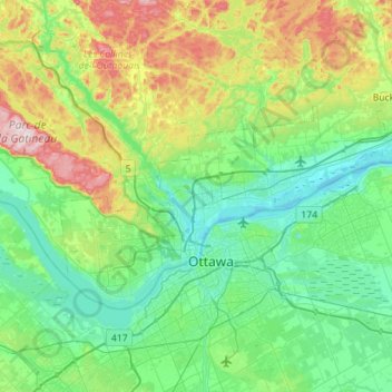
Name: Gatineau topographic map, elevation, terrain.
Location: Gatineau, Outaouais, Quebec, Canada (45.37238 -75.90835 45.59912 -75.34423)
Average elevation: 127 m
Minimum elevation: 39 m
Maximum elevation: 409 m
Gatineau is located in southwestern Quebec, on the northern bank of the Gatineau River. It is situated at an elevation of around 50 m (164.042 ft) The Gatineau Hills are the foothills of the Laurentian Mountains and located in the region. It is also the location of the second largest urban park in the world. They supply great skiing and snowboarding opportunities within minutes of the city. Gatineau is situated close to where the Canadian shield and the Saint Lawrence Lowlands intersect. The area has several major fault lines and small earthquakes do occur somewhat regularly, on average, there are at least one earthquake of intensity III or higher once every three years in Ottawa-Gatineau. The most memorable being the 2010 Central Canada earthquake that occurred in Quebec. The epicentre was situated approximately 56 kilometres (35 mi) north of Ottawa, Ontario, in the municipality of Val-des-Bois, Quebec.
Other topographic maps
Click on a map to view its topography, its elevation and its terrain.
Quebec
Canada > Quebec > Urban agglomeration of Québec
Quebec, Urban agglomeration of Québec, Capitale-Nationale, Quebec, Canada
Average elevation: 117 m
Chelsea
Canada > Quebec > Les Collines-de-l'Outaouais
Chelsea, Les Collines-de-l'Outaouais, Outaouais, Quebec, Canada
Average elevation: 166 m
Montreal
Canada > Quebec > Urban agglomeration of Montreal > Montreal
Montreal, Urban agglomeration of Montreal, Montreal (06), Quebec, H3B 1M7, Canada
Average elevation: 30 m
Les Îles-de-la-Madeleine
Canada > Quebec > Les Îles-de-la-Madeleine
Les Îles-de-la-Madeleine, communauté maritime des Îles-de-la-Madeleine, Gaspésie–Îles-de-la-Madeleine, Quebec, Canada
Average elevation: 2 m
Lac Caron
Canada > Quebec > Shawinigan > Shawinigan
Lac Caron, Shawinigan, Mauricie, Quebec, Canada
Average elevation: 228 m
Shawinigan
Canada > Quebec > Shawinigan > Shawinigan
Shawinigan, Mauricie, Quebec, G9N 1G6, Canada
Average elevation: 137 m
Delson
Canada > Quebec > Roussillon > Delson
Delson, Roussillon, Montérégie, Quebec, Canada
Average elevation: 27 m
Montreal
Canada > Quebec > Urban agglomeration of Montreal
Montreal, Urban agglomeration of Montreal, Montreal (administrative region), Quebec, Canada
Average elevation: 30 m
Lac-Pikauba
Canada > Quebec > Lac-Pikauba
Lac-Pikauba, Charlevoix, Capitale-Nationale, Quebec, Canada
Average elevation: 736 m
Sainte-Marthe
Canada > Quebec > Sainte-Marthe
Sainte-Marthe, Vaudreuil-Soulanges, Montérégie, Quebec, J0P 1W0, Canada
Average elevation: 77 m
Repentigny
Canada > Quebec > Repentigny
Repentigny, L'Assomption (MRC), Lanaudière, Quebec, Canada
Average elevation: 14 m
Rosemont–La Petite-Patrie
Rosemont–La Petite-Patrie, Montreal, Urban agglomeration of Montreal, Montreal (06), Quebec, Canada
Average elevation: 50 m
Pointe-à-la-Croix
Canada > Quebec > Pointe-à-la-Croix
Pointe-à-la-Croix, Avignon, Gaspésie–Îles-de-la-Madeleine, Quebec, G0C 1L0, Canada
Average elevation: 6 m
Gaspésie–Îles-de-la-Madeleine
Gaspésie–Îles-de-la-Madeleine, Quebec, Canada
Average elevation: 86 m
Lac Saint-Pierre
Canada > Quebec > Pierreville
Lac Saint-Pierre, Rang du Chenal-Tardif, Pierreville, Nicolet-Yamaska, Centre-du-Québec, Quebec, Canada
Average elevation: 25 m
Anticosti Island
Canada > Quebec > Anticosti Island
Anticosti Island, Minganie, Côte-Nord, Quebec, Canada
Average elevation: 30 m
Charlesbourg
Canada > Quebec > Charlesbourg
Charlesbourg, Québec (Agglomération), Capitale-Nationale, Quebec, Canada
Average elevation: 177 m
Saint Lawrence River
Saint Lawrence River, Rue De Gaspé, Verdun, Montreal, Urban agglomeration of Montreal, Montreal (06), Quebec, H3E 1H2, Canada
Average elevation: 14 m
Lake Memphremagog
Lake Memphremagog, Chemin Girl's Camp, Potton, Memphrémagog, Estrie, Quebec, Canada
Average elevation: 311 m
Gulf of Saint Lawrence
Gulf of Saint Lawrence, Minganie, Côte-Nord, Quebec, Canada
Average elevation: 167 m
Mont-Tremblant
Canada > Quebec > Mont-Tremblant
Mont-Tremblant, Les Laurentides, Laurentides, Quebec, Canada
Average elevation: 358 m
Ville-Marie
Ville-Marie, Montreal, Urban agglomeration of Montreal, Montreal (06), Quebec, Canada
Average elevation: 30 m