
Paraná topographic map
Interactive map
Click on the map to display elevation.
About this map
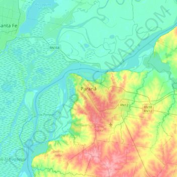
Name: Paraná topographic map, elevation, terrain.
Average elevation: 34 m
Minimum elevation: 6 m
Maximum elevation: 121 m
Other topographic maps
Click on a map to view its topography, its elevation and its terrain.
Paraná
Argentina > Entre Ríos > Paraná
Paraná, Distrito Sauce, Departamento Paraná, Entre Ríos, Argentina
Average elevation: 50 m
Parque Urquiza
Argentina > Entre Ríos > Paraná
Parque Urquiza, Puerto Sánchez, Bajada Grande, Paraná, Distrito Sauce, Departamento Paraná, Entre Ríos, Argentina
Average elevation: 34 m