
Bergamo topographic map
Interactive map
Click on the map to display elevation.
About this map
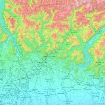
Name: Bergamo topographic map, elevation, terrain.
Location: Bergamo, Lombardy, Italy (45.42216 9.44505 46.09120 10.26275)
Average elevation: 697 m
Minimum elevation: 80 m
Maximum elevation: 3,014 m
Other topographic maps
Click on a map to view its topography, its elevation and its terrain.
Forte di Pietole
Italy > Lombardy > Mantua > Borgo Virgilio > Pietole > Pietole Vecchia
Average elevation: 19 m
Trepalle
Italy > Lombardy > Sondrio > Livigno
Trepalle is a village (the highest in Italy) in the Italian Alps, a frazione of Livigno, Lombardy. It is sometimes considered to be the village located at the highest altitude in Europe with its church located at an altitude of 2,069 m, and the village stretching up to the Passo d'Eira at 2,209 m. However,…
Average elevation: 2,236 m