
Greenville County topographic map
Interactive map
Click on the map to display elevation.
About this map
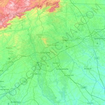
Name: Greenville County topographic map, elevation, terrain.
Location: Greenville County, South Carolina, USA (34.48406 -82.76441 35.21549 -82.14696)
Average elevation: 308 m
Minimum elevation: 135 m
Maximum elevation: 1,130 m
Other topographic maps
Click on a map to view its topography, its elevation and its terrain.
Kiawah Island
USA > South Carolina > Kiawah Island
Kiawah Island, Charleston County, South Carolina, USA
Average elevation: 2 m
Red Hill
USA > South Carolina > Red Hill
Red Hill, Horry County, South Carolina, USA
Average elevation: 9 m
Hilton Head Island
USA > South Carolina > Hilton Head Island
Hilton Head Island, Beaufort County, South Carolina, USA
Average elevation: 2 m
Abbeville
USA > South Carolina > Abbeville
Abbeville, Abbeville County, South Carolina, USA
Average elevation: 174 m
Simmonsville
USA > South Carolina > Simmonsville
Simmonsville, Georgetown County, South Carolina, USA
Average elevation: 5 m
Tenmile
USA > South Carolina > Tenmile
Tenmile, Charleston County, South Carolina, 29416, USA
Average elevation: 9 m
Pine Creek
USA > South Carolina > Pine Creek
Pine Creek, Kershaw County, South Carolina, 29020, USA
Average elevation: 73 m
Cape Romain National Wildlife Refuge
USA > South Carolina > Awendaw
Cape Romain National Wildlife Refuge, Awendaw, Charleston County, South Carolina, USA
Average elevation: 3 m