
Champaign County topographic map
Interactive map
Click on the map to display elevation.
About this map
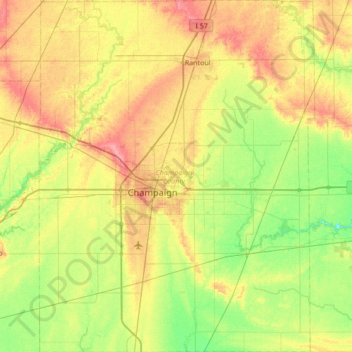
Name: Champaign County topographic map, elevation, terrain.
Location: Champaign County, Illinois, USA (39.87910 -88.46357 40.40068 -87.92882)
Average elevation: 217 m
Minimum elevation: 187 m
Maximum elevation: 260 m
Other topographic maps
Click on a map to view its topography, its elevation and its terrain.
Vernon Hills
USA > Illinois > Vernon Hills
Vernon Hills, Lake County, Illinois, 60061, USA
Average elevation: 219 m
Mount Carmel
USA > Illinois > Mount Carmel
Mount Carmel, Wabash County, Illinois, USA
Average elevation: 128 m
Montague Island
Montague Island, Rockford, Winnebago County, Illinois, 61104, USA
Average elevation: 254 m
Garfield Ridge
Garfield Ridge, Chicago, Cook County, Illinois, USA
Average elevation: 184 m