
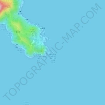
Cheung Tsui Chau topographic map
Interactive map
Click on the map to display elevation.
About this map
Name: Cheung Tsui Chau topographic map, elevation, terrain.
Average elevation: 8 m
Minimum elevation: 0 m
Maximum elevation: 196 m
Other topographic maps
Click on a map to view its topography, its elevation and its terrain.
Wong Mau Chau
Wong Mau Chau, Tung Wan, Sai Kung District, Hong Kong, PRC
Average elevation: 3 m
Breaker Reef
Breaker Reef, Shore of Thousand Creek (Chin Kai Hoi On), Tai Long, Tung Wan, Sai Kung District, Hong Kong, PRC
Average elevation: 0 m