
Tepeji del Río de Ocampo topographic map
Interactive map
Click on the map to display elevation.
About this map
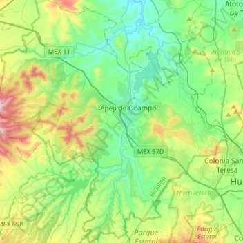
Name: Tepeji del Río de Ocampo topographic map, elevation, terrain.
Location: Tepeji del Río de Ocampo, Hidalgo, Mexico (19.77120 -99.48398 20.01632 -99.23595)
Average elevation: 2,296 m
Minimum elevation: 2,043 m
Maximum elevation: 2,942 m
Other topographic maps
Click on a map to view its topography, its elevation and its terrain.
Santiago Tulantepec
Mexico > Hidalgo > Santiago Tulantepec de Lugo Guerrero
Average elevation: 2,260 m
Col. Loma Bonita
Mexico > Hidalgo > Atotonilco de Tula > Atotonilco de Tula > Col. Loma Bonita
Average elevation: 2,164 m
Pachuca
Mexico > Hidalgo > Pachuca de Soto
Pachuca has a semi-arid climate (Köppen climate classification BSk). The climate is cool with high rainfall and occasional hail during the summer months and dry conditions during the winter. The coldest month is January, with an average high of 20 °C (68 °F) and an average low of 3 °C (37 °F). Winter…
Average elevation: 2,459 m