
Perlis topographic map
Interactive map
Click on the map to display elevation.
Perlis
From south to north, its topographical profile consists of flat, arable lands of the Kedah–Perlis Plain dotted with numerous mogotes, and abruptly rises up high as rolling karstic hills of the Nakawan Range, which forms the natural boundary between the state and the province of Satun on the Thai side. In general, paddy fields dominate much of the state's landscape as the Perlisian portion of the Kedah–Perlis Plain had been utilized for rice farming since antiquity. Meanwhile, the Nakawan runs southwest–northeast along the Thai border from Kuala Perlis towards Kaki Bukit. The range is home to the 733-metre tall Mount Perlis, the highest point in the state.
About this map
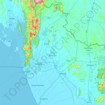
Name: Perlis topographic map, elevation, terrain.
Location: Perlis, Malaysia (6.25327 100.12042 6.72608 100.37068)
Average elevation: 50 m
Minimum elevation: -2 m
Maximum elevation: 714 m
Other topographic maps
Click on a map to view its topography, its elevation and its terrain.
Sibu
Sibu is located near the Rajang delta at the confluence of Rajang and Igan rivers. Peat swamp forests and alluvial plains are particularly prevalent in the Sibu Division. Sibu is located on a deep peat soil, which has caused problems in infrastructure development because buildings and roads slowly sink into…
Average elevation: 10 m
Pahang
The highest peak, Mount Tahan, reaches 2,187 m (7,175 ft) in elevation, which is also the highest point in the Peninsular Malaysia. The climate is temperate enough to have distinct temperature variations year round, and much of the highlands are covered with tropical rainforest. Pahang is home to Malaysia's…
Average elevation: 90 m
Penang Island
Penang Island is irregularly shaped, with a hilly and mostly forested interior; its coastal plains are narrow, the most extensive of which is at the northeastern cape. With a height of 833 m (2,733 ft), Penang Hill, at the centre of the island, is the tallest point within Penang. From a small settlement at the…
Average elevation: 117 m
Kampung Orang Asli Kuala Pangsun
Malaysia > Selangor > Kajang Municipal Council
Average elevation: 235 m
Kuala Lumpur
Located in the centre of Selangor state, Kuala Lumpur was a territory of Selangor State Government. In 1974, Kuala Lumpur was split off from Selangor to form the first Federal Territory governed directly by the Malaysian federal government. Its location in the most developed state on the west coast of…
Average elevation: 127 m
Seri Iskandar
Seri Iskandar (Jawi: سري إسكندر, Chinese: 斯里依斯干达) is a major town within the Perak Tengah District in the state of Perak, Malaysia. It is situated about 40 kilometers southwest of the city of Ipoh, the state capital. The town is at an average elevation of 29 meters above the sea level. The…
Average elevation: 29 m
Cameron Highlands
Surveyed by the government geologist and explorer William Cameron in 1885, the outpost consists of three mukims (subdistricts), namely Ringlet, Tanah Rata and Ulu Telom. Its eight settlements are Ringlet, Tanah Rata (the administrative centre), Brinchang, the Bertam Valley, Kea Farm, Tringkap, Kampung Kuala…
Average elevation: 1,400 m
Genting Highlands
Genting Highlands is a hill station and a city located on the peak of Mount Ulu Kali in the Titiwangsa Mountains, central Peninsular Malaysia, at 1800 metres elevation. It is the second seat of Bentong District after Bentong. Located in the state of Pahang. It was established in 1965 by the late Malaysian…
Average elevation: 1,141 m
Batu Metropolitan Park
Malaysia > Kuala Lumpur > Kuala Lumpur > Kampung Sri Batu
Average elevation: 47 m
Padang SMK Jengka Pusat
Malaysia > Pahang > Bandar Tun Abdul Razak (Bandar Jengka)
Average elevation: 75 m
Brinchang
Brinchang (also spelt Berincang) is a town and hill resort located at an altitude of 1,540 metres (5,050 ft) in Cameron Highlands in the state of Pahang, Malaysia. The town's name is derived from nearby Gunung Brinchang, which is the second highest point in Cameron Highlands.
Average elevation: 1,524 m
Sungei Palas Boh Plantation Viewpoint
Malaysia > Pahang > Cameron Highlands
Average elevation: 1,536 m
Mount Kinabalu
Mount Kinabalu (Malay: Gunung Kinabalu, Dusun: Gayo Ngaran or Nulu Nabalu) is the highest mountain in Borneo and Malaysia. With an elevation of 13,435 feet (4,095 m), it is third-highest peak of an island on Earth, and 20th most prominent mountain in the world by topographic prominence. The mountain is located…
Average elevation: 3,567 m