
Leiria topographic map
Interactive map
Click on the map to display elevation.
About this map
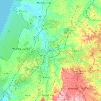
Name: Leiria topographic map, elevation, terrain.
Location: Leiria, Pinhal Litoral, Centro, 2400-217 LEIRIA, Portugal (39.58379 -8.96711 39.90379 -8.64711)
Average elevation: 145 m
Minimum elevation: 0 m
Maximum elevation: 522 m
Other topographic maps
Click on a map to view its topography, its elevation and its terrain.
Pimenteira
Pimenteira, Leiria, Pinhal Litoral, Centro, 2420-124, Portugal
Average elevation: 172 m