
Fort Peck topographic map
Interactive map
Click on the map to display elevation.
About this map
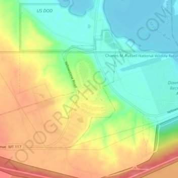
Name: Fort Peck topographic map, elevation, terrain.
Location: Fort Peck, Valley County, Montana, United States (48.00077 -106.47954 48.01857 -106.44172)
Average elevation: 652 m
Minimum elevation: 618 m
Maximum elevation: 693 m
Other topographic maps
Click on a map to view its topography, its elevation and its terrain.
Fort Peck Lake
United States > Montana > Valley County
Fort Peck Lake, Valley County, Montana, 59223, United States
Average elevation: 783 m
Dead Mans Hill
United States > Montana > Valley County
Dead Mans Hill, Valley County, Montana, United States
Average elevation: 728 m
Glasgow
United States > Montana > Valley County > Glasgow
Glasgow, Valley County, Montana, 59230, United States
Average elevation: 654 m