
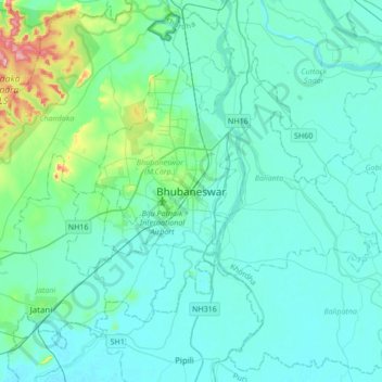
Bhubaneshwar topographic map
Interactive map
Click on the map to display elevation.
About this map
Name: Bhubaneshwar topographic map, elevation, terrain.
Average elevation: 30 m
Minimum elevation: 6 m
Maximum elevation: 199 m
Bhubaneswar is in Khordha district of Odisha. It is in the eastern coastal plains, along the axis of the Eastern Ghats mountains. The city has an average altitude of 45 m (148 ft) above sea level. It lies southwest of the Mahanadi River that forms the northern boundary of Bhubaneswar metropolitan area, within its delta.
Other topographic maps
Click on a map to view its topography, its elevation and its terrain.
Bhubaneswar Municipal Corporation
India > Odisha > Bhubaneswar (M.Corp.)
Bhubaneswar Municipal Corporation, Bhubaneswar (M.Corp.), Khordha, Odisha, India
Average elevation: 37 m
Vani Vihar
India > Odisha > Bhubaneswar (M.Corp.) > Bhubaneswar Municipal Corporation
Vani Vihar, Bhubaneswar Municipal Corporation, Bhubaneswar (M.Corp.), Khordha, Odisha, India
Average elevation: 40 m
Ward 16
India > Odisha > Bhubaneswar (M.Corp.) > Bhubaneswar Municipal Corporation
Ward 16, North Zone, Bhubaneswar Municipal Corporation, Bhubaneswar (M.Corp.), Khordha, Odisha, India
Average elevation: 57 m
Ward 30
India > Odisha > Bhubaneswar (M.Corp.) > Bhubaneswar Municipal Corporation
Ward 30, Saheed Nagar, Bhubaneswar Municipal Corporation, Bhubaneswar (M.Corp.), Khordha, Odisha, 751007, India
Average elevation: 36 m