
Hangzhou City topographic map
Interactive map
Click on the map to display elevation.
About this map
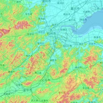
Name: Hangzhou City topographic map, elevation, terrain.
Location: Hangzhou City, Zhejiang, China (29.18883 118.33969 30.56485 120.72549)
Average elevation: 186 m
Minimum elevation: -2 m
Maximum elevation: 1,543 m
Other topographic maps
Click on a map to view its topography, its elevation and its terrain.
Tonglu County
Tonglu County, Hangzhou City, Zhejiang, 311500, China
Average elevation: 255 m
Dongxin
China > Zhejiang > Gongshu District > Dongxin
Dongxin, Gongshu District, Hangzhou City, Zhejiang, 310004, China
Average elevation: 10 m