
Ingelheim am Rhein topographic map
Interactive map
Click on the map to display elevation.
About this map
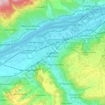
Name: Ingelheim am Rhein topographic map, elevation, terrain.
Average elevation: 157 m
Minimum elevation: 78 m
Maximum elevation: 449 m
Other topographic maps
Click on a map to view its topography, its elevation and its terrain.
Wintersheim
Deutschland > Rheinland-Pfalz > Landkreis Mainz-Bingen
Wintersheim, Rhein-Selz, Landkreis Mainz-Bingen, Rheinland-Pfalz, 67587, Deutschland
Average elevation: 198 m
Breitscheid
Deutschland > Rheinland-Pfalz > Landkreis Mainz-Bingen > Breitscheid
Breitscheid, Rhein-Nahe, Landkreis Mainz-Bingen, Rheinland-Pfalz, Deutschland
Average elevation: 401 m