
Borough of Luton topographic map
Interactive map
Click on the map to display elevation.
About this map
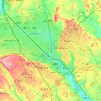
Name: Borough of Luton topographic map, elevation, terrain.
Location: Borough of Luton, England, United Kingdom (51.85447 -0.50595 51.92774 -0.34992)
Average elevation: 146 m
Minimum elevation: 94 m
Maximum elevation: 215 m
The local climate around Luton is differentiated somewhat from much of South East England due to its position in the Chiltern Hills, meaning it tends to be 1–2 degrees Celsius cooler than the surrounding towns – often flights at Luton airport, lying 160 m (525 ft) above sea level, will be suspended when marginal snow events occur, while airports at lower elevations, such as Heathrow, at 25 m (82 ft) above sea level, continue to function. An example of this is shown in the photograph to the right, the snowline being about 100 m (328 ft) above sea level. Absolute temperature extremes recorded at Rothamsted Research Station, 5 miles (8 km) south south east of Luton town centre and at a similar elevation range from −17.0 °C (1.4 °F) in December 1981 and −16.7 °C (1.9 °F) in January 1963 to 36.6 °C (97.9 °F) in July 2019 and 33.8 °C (92.8 °F) in August 1990 and July 2006. Records for Rothamsted date back to 1901.
Other topographic maps
Click on a map to view its topography, its elevation and its terrain.
London
United Kingdom > England > London
London, Greater London, England, SW1A 2DX, United Kingdom
Average elevation: 42 m
Bristol
United Kingdom > England > City of Bristol
Bristol, City of Bristol, West of England, England, United Kingdom
Average elevation: 55 m
London
London, Greater London, England, United Kingdom
Average elevation: 66 m
Liverpool
Liverpool, Liverpool City Region, England, United Kingdom
Average elevation: 26 m
Nottingham
United Kingdom > England > Nottinghamshire
Nottingham, England, United Kingdom
Average elevation: 56 m
Birmingham
Birmingham, West Midlands Combined Authority, England, United Kingdom
Average elevation: 138 m
Bath
United Kingdom > England > Bath and North East Somerset
Bath, Bath and North East Somerset, West of England, England, United Kingdom
Average elevation: 100 m
Sheffield
Sheffield, South Yorkshire, England, United Kingdom
Average elevation: 168 m
City of London
United Kingdom > England > City of London > City of London
City of London, England, EC2V 5AE, United Kingdom
Average elevation: 42 m
Brighton
United Kingdom > England > Brighton and Hove
Brighton, Brighton and Hove, England, United Kingdom
Average elevation: 64 m
Plymouth
United Kingdom > England > Devon > Plymouth
Plymouth, Devon, South West England, England, PL1 1HH, United Kingdom
Average elevation: 81 m
Hull
United Kingdom > England > Kingston upon Hull
Hull, Kingston upon Hull, England, HU1 3RJ, United Kingdom
Average elevation: 21 m
Greater London
Greater London, England, United Kingdom
Average elevation: 66 m
Buckinghamshire
United Kingdom > England > Buckinghamshire
Buckinghamshire, Greater London, England, United Kingdom
Average elevation: 103 m
Oxford
United Kingdom > England > Oxfordshire
Oxford, Oxfordshire, England, United Kingdom
Average elevation: 81 m
Newcastle upon Tyne
Newcastle upon Tyne, North of Tyne, England, United Kingdom
Average elevation: 57 m
Lincolnshire
Lincolnshire, East Midlands, England, United Kingdom
Average elevation: 28 m
Greater Manchester
Greater Manchester, England, United Kingdom
Average elevation: 141 m
Norwich
United Kingdom > England > Norfolk
Norwich, Norfolk, England, United Kingdom
Average elevation: 28 m
Cambridge
United Kingdom > England > Cambridge
Cambridge, Cambridgeshire, East of England, England, United Kingdom
Average elevation: 18 m
Guildford
United Kingdom > England > Surrey
Guildford, Surrey, England, United Kingdom
Average elevation: 74 m
Cheltenham
United Kingdom > England > Gloucestershire
Cheltenham, Gloucestershire, England, United Kingdom
Average elevation: 109 m
Chichester
United Kingdom > England > Chichester
Chichester, West Sussex, South East, England, United Kingdom
Average elevation: 57 m
St Albans
United Kingdom > England > Hertfordshire > St Albans
St Albans, Hertfordshire, East of England, England, United Kingdom
Average elevation: 100 m
Coventry
Coventry, West Midlands Combined Authority, England, United Kingdom
Average elevation: 99 m
North West England
North West England, England, United Kingdom
Average elevation: 118 m
King's Lynn and West Norfolk
United Kingdom > England > Norfolk
King's Lynn and West Norfolk, Norfolk, England, United Kingdom
Average elevation: 20 m
Lund
United Kingdom > England > North Yorkshire > Selby
Lund, Cliffe, Selby, North Yorkshire, England, YO8 6PD, United Kingdom
Average elevation: 6 m
Soils Wood
United Kingdom > England > Essex > Great Oakley
Soils Wood, Great Oakley, Tendring, Essex, England, United Kingdom
Average elevation: 15 m
East Riding of Yorkshire
East Riding of Yorkshire, England, United Kingdom
Average elevation: 30 m
Poole
United Kingdom > England > Bournemouth, Christchurch and Poole > Poole
Poole, Bournemouth, Christchurch and Poole, England, United Kingdom
Average elevation: 23 m
Devizes
United Kingdom > England > Devizes
Devizes, Wiltshire, South West England, England, SN10, United Kingdom
Average elevation: 109 m
Salisbury
United Kingdom > England > Salisbury
Salisbury, Wiltshire, South West England, England, SP1 1EU, United Kingdom
Average elevation: 96 m
Doncaster
Doncaster, South Yorkshire, England, United Kingdom
Average elevation: 31 m
The Cotswolds National Landscape
United Kingdom > England > Gloucestershire
The Cotswolds National Landscape, Gloucestershire, West of England, England, United Kingdom
Average elevation: 109 m
Stroud
United Kingdom > England > Gloucestershire
Stroud, Gloucestershire, England, United Kingdom
Average elevation: 113 m
Lancaster
United Kingdom > England > Lancashire
Lancaster, Lancashire, England, United Kingdom
Average elevation: 84 m