
Newaygo County topographic map
Interactive map
Click on the map to display elevation.
About this map
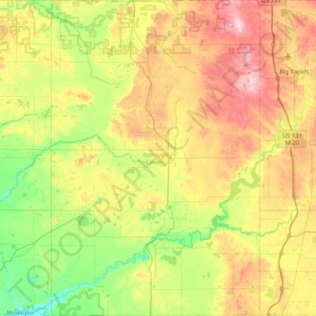
Name: Newaygo County topographic map, elevation, terrain.
Location: Newaygo County, Michigan, United States (43.29289 -86.03978 43.81548 -85.56224)
Average elevation: 266 m
Minimum elevation: 177 m
Maximum elevation: 406 m
Other topographic maps
Click on a map to view its topography, its elevation and its terrain.
Carpenter Lake Nature Preserve
United States > Michigan > Oakland County > Southfield
Average elevation: 207 m
Point Abbaye Natural Area Baraga County Park
United States > Michigan > Baraga County
Average elevation: 181 m
Edgewater Heights
United States > Michigan > Wayne County > Van Buren Charter Township
Average elevation: 208 m
West Canadian Lake
United States > Michigan > Mecosta County > Canadian Lakes
Average elevation: 295 m
Genessee County Recreational Area
United States > Michigan > Genesee County > Flint
Average elevation: 231 m
Seven Harbors
United States > Michigan > Oakland County > Highland Charter Township
Average elevation: 314 m
Detroit
United States > Michigan > Wayne County
The city slopes gently from the northwest to southeast on a till plain composed largely of glacial and lake clay. The most notable topographical feature in the city is the Detroit Moraine, a broad clay ridge on which the older portions of Detroit and Windsor are located, rising approximately 62 feet (19 m)…
Average elevation: 186 m