
Village of Mamaroneck topographic map
Interactive map
Click on the map to display elevation.
About this map
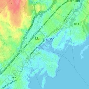
Name: Village of Mamaroneck topographic map, elevation, terrain.
Average elevation: 15 m
Minimum elevation: -3 m
Maximum elevation: 65 m
Other areas of the town include Heathcote Hill, overlooking the harbor, Harbor Heights (the heights) to the northeast, Old Rye Neck (settled in the 1880s), Rye Neck (settled in the 1920s and 1930s), Orienta, and Washingtonville, better known as "The Flats", due to the flat, low-lying topography of the area.
Other topographic maps
Click on a map to view its topography, its elevation and its terrain.
Village of Larchmont
United States > New York > Westchester County > Town of Mamaroneck
Village of Larchmont, Town of Mamaroneck, Westchester County, New York, 10538, United States
Average elevation: 8 m